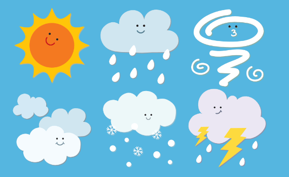
Weather
Natural Disasters

Experiments
Kid's Zone
Thunderstorms
- Thunderstorm Questions
- Lightning Questions
- Hail Questions
- Damaging Wind Questions
- Thunderstorm Definitions
- Thunderstorm Facts
- Thunderstorm Safety
- Thunderstorm Activities
What is a thunderstorm?
A thunderstorm is a storm with lightning and thunder. Its produced by a cumulonimbus cloud, usually producing gusty winds, heavy rain and sometimes hail.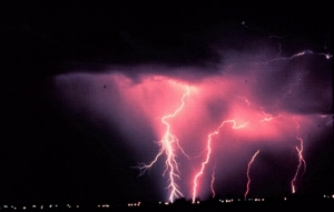
What causes a thunderstorm?
The basic ingredients used to make a thunderstorm are moisture, unstable air and lift. You need moisture to form clouds and rain. You need unstable air that is relatively warm and can rise rapidly. Finally, you need lift. This can form from fronts, sea breezes or mountains.
What is a severe thunderstorm?
A thunderstorm is classified as “severe” when it contains one or more of the following: hail one inch or greater, winds gusting in excess of 58 mph (50 knots), or a tornado.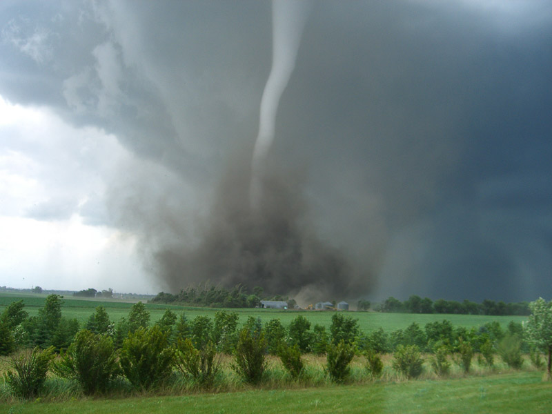
Where are severe thunderstorms most common?
The greatest severe weather threat in the U.S. extends from Texas to southern Minnesota. But, no place in the United States is completely safe from the threat of severe weather.
What are the stages of a thunderstorm?
Thunderstorms have three stages in their life cycle: The developing stage, the mature stage, and the dissipating stage. The developing stage of a thunderstorm is marked by a cumulus cloud that is being pushed upward by a rising column of air (updraft). The cumulus cloud soon looks like a tower (called towering cumulus) as the updraft continues to develop. There is little to no rain during this stage but occasional lightning. The thunderstorm enters the mature stage when the updraft continues to feed the storm, but precipitation begins to fall out of the storm, creating a downdraft (a column of air pushing downward). When the downdraft and rain-cooled air spreads out along the ground it forms a gust front, or a line of gusty winds. The mature stage is the most likely time for hail, heavy rain, frequent lightning, strong winds, and tornadoes. Eventually, a large amount of precipitation is produced and the updraft is overcome by the downdraft beginning the dissipating stage. At the ground, the gust front moves out a long distance from the storm and cuts off the warm moist air that was feeding the thunderstorm. Rainfall decreases in intensity, but lightning remains a danger.
What is a single-cell thunderstorm?
Often called “popcorn” convection, single-cell thunderstorms are small, brief, weak storms that grow and die within an hour or so. They are typically driven by heating on a summer afternoon. Single-cell storms may produce brief heavy rain and lightning.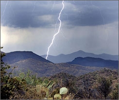
What is a multi-cell thunderstorm?
A multi-cell storm is a common, garden-variety thunderstorm in which new updrafts form along the leading edge of rain-cooled air or the gust front. Individual cells usually last 30 to 60 minutes, while the system as a whole may last for many hours. Multicell storms may produce hail, strong winds, brief tornadoes, and/or flooding.
What is a squall line?
A squall line is a group of storms arranged in a line, often accompanied by “squalls” of high wind and heavy rain. Squall lines tend to pass quickly and are less prone to produce tornadoes than are supercells. They can be hundreds of miles long but are typically only 10 or 20 miles wide.
What is a supercell thunderstorm?
A supercell is a long-lived (greater than 1 hour) and highly organized storm feeding off an updraft (a rising current of air) that is tilted and rotating. This rotating updraft – as large as 10 miles in diameter and up to 50,000 feet tall – can be present as much as 20 to 60 minutes before a tornado forms. Scientists call this rotation a mesocyclone when it is detected by Doppler radar. The tornado is a very small extension of this larger rotation. Most large and violent tornadoes come from supercells.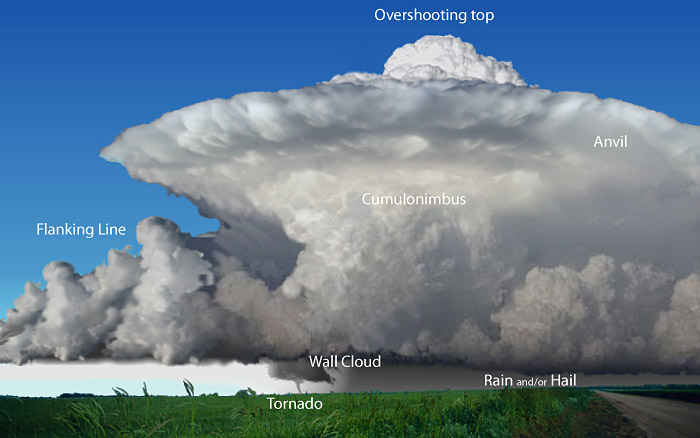
What is a bow echo?
A “bow echo” is a radar signature of a squall line that “bows out” as winds fall behind the line and circulations develop on either end. A strongly bowed echo may indicate high winds in the middle of the line, where the storms are moving forward most quickly. Brief tornadoes may occur on the leading edge of a bow echo. Often the north side of a bow echo becomes dominant over time, gradually evolving into a comma-shaped storm complex.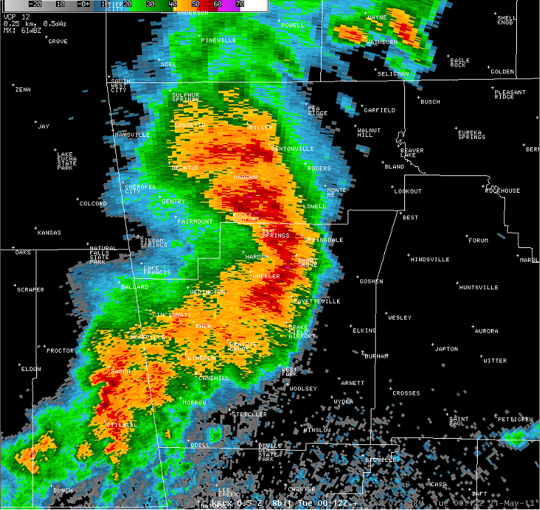
What is a Mesoscale Convective System?
A Mesoscale Convective System (MCS) is a collection of thunderstorms that act as a system. An MCS can spread across an entire state and last more than 12 hours. On radar one of these monsters might appear as a solid line, a broken line, or a cluster of cells. This all-encompassing term can include any of the following storm types:
- Mesoscale convective complex (MCC)—A particular type of MCS, an MCC is a large, circular, long-lived cluster of showers and thunderstorms identified by satellite. It often emerges out of other storm types during the late-night and early-morning hours. MCCs can cover an entire state.
- Mesoscale convective vortex (MCV)—A low-pressure center within an MCS that pulls winds into a circling pattern, or vortex. With a core only 30 to 60 miles wide and 1 to 3 miles deep, an MCV is often overlooked in standard weather analyses. But an MCV can take on a life of its own, persisting for up to 12 hours after its parent MCS has dissipated. This orphaned MCV will sometimes then become the seed of the next thunderstorm outbreak. An MCV that moves into tropical waters, such as the Gulf of Mexico, can serve as the nucleus for a tropical storm or hurricane.
What does a thunderstorm look like?
Thunderstorms can look like tall heads of cauliflower or they can have “anvils.” An anvil is the flat cloud formation at the top of the storm. An anvil forms when the updraft (warm air rising) has reached a point where the surrounding air is about the same temperature or even warmer. The cloud growth abruptly stops and flattens out to take the shape of an anvil.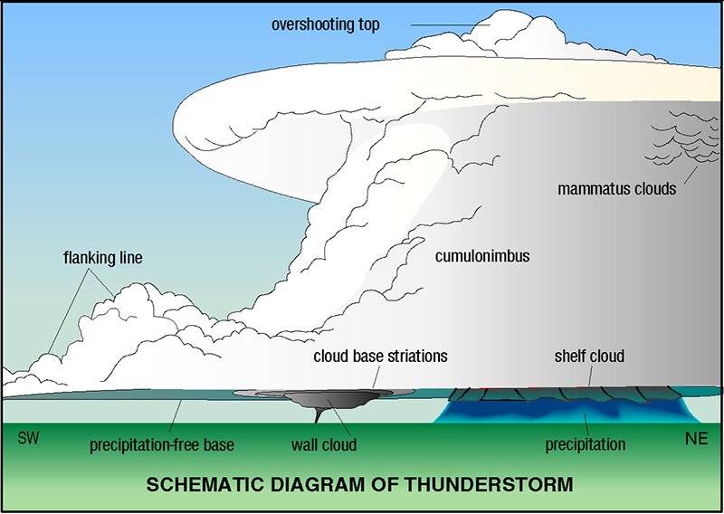
When are thunderstorms most likely to occur?
Thunderstorms can occur year-round and at all hours. But they are most likely to happen in the spring and summer months and during the afternoon and evening hours. Along the Gulf Coast and across the southeastern and western states, most thunderstorms occur during the afternoon. Thunderstorms frequently occur in the late afternoon and at night in the Plains states.
How many thunderstorms are there?
Worldwide, there are an estimated 16 million thunderstorms each year, and at any given moment, there are roughly 2,000 thunderstorms in progress. There are about 100,000 thunderstorms each year in the U.S. alone. About 10% of these reach severe levels.
What kinds of damage can thunderstorms cause?
Many hazardous weather events are associated with thunderstorms. Under the right conditions, rainfall from thunderstorms causes flash flooding, killing more people each year than hurricanes, tornadoes or lightning. Lightning is responsible for many fires around the world each year, and causes fatalities. Hail up to the size of softballs damages cars and windows, and kills livestock caught out in the open. Strong (up to more than 120 mph) straight-line winds associated with thunderstorms knock down trees, power lines and mobile homes. Tornadoes (with winds up to about 300 mph) can destroy all but the best-built man-made structures.
Why do I sometimes hear meteorologists use the word “convection” when talking about thunderstorms?
Usually created by surface heating, convection is upward atmospheric motion that transports whatever is in the air along with it—especially any moisture available in the air. A thunderstorm is the result of convection.
What is SKYWARN?
SKYWARN is a National Weather program that is run by and coordinated by the NWS. It was a concept developed in the early 1970’s that was intended to promote a cooperative effort between the National Weather Service and its communities. The emphasis of the effort is often focused on the storm spotter, a volunteer who takes a position near their community and reports wind gusts, hail size, rainfall, and cloud formations that could signal a developing tornado. YOU can be trained to be a SKYWARN spotter. Visit www.skywarn.org to find a link to local SKYWARN groups. If your area is not listed, contact your local National Weather Service Office.
What is lightning?
Lightning is a bright flash of electricity produced by a thunderstorm. All thunderstorms produce lightning and are very dangerous. If you hear the sound of thunder, then you are in danger from lightning. Lightning kills and injures more people each year than hurricanes or tornadoes; between 75 to 100 people.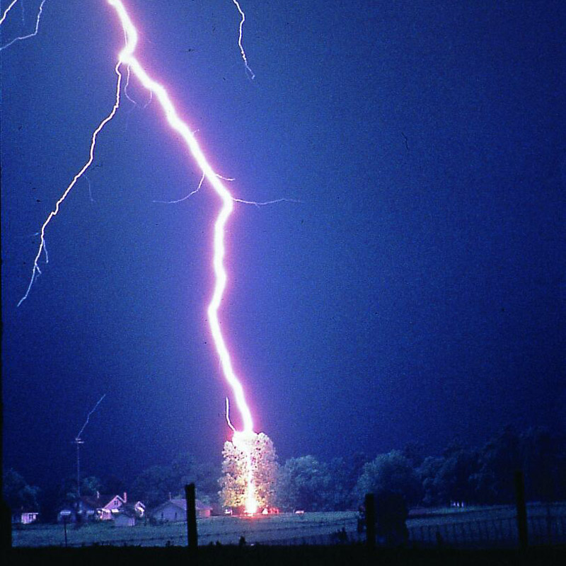
What causes lightning?
Lightning is an electric current. Within a thundercloud way up in the sky, many small bits of ice (frozen raindrops) bump into each other as they move around in the air. All of those collisions create an electric charge. After a while, the whole cloud fills up with electrical charges. The positive charges or protons form at the top of the cloud and the negative charges or electrons form at the bottom of the cloud. Since opposites attract, that causes a positive charge to build up on the ground beneath the cloud. The grounds electrical charge concentrates around anything that sticks up, such as mountains, people, or single trees. The charge coming up from these points eventually connects with a charge reaching down from the clouds and – zap – lightning strikes!
Have you ever rubbed your feet across carpet and then touched a metal door handle? If so, then you know that you can get shocked! Lightning works in the same way.
Click Here to see where lightning is currently striking across the U.S.
What causes thunder?
Thunder is caused by lightning. When a lightning bolt travels from the cloud to the ground it actually opens up a little hole in the air, called a channel. Once then light is gone the air collapses back in and creates a sound wave that we hear as thunder. The reason we see lightning before we hear thunder is because light travels faster than sound!
How do you know if lightning is nearby?
If you see dark clouds, then lightning could be present, but the best thing you can do is to listen for thunder. If you hear thunder, then you need to go indoors or get in a car. Don’t be outside, where lightning could strike! If your hair stands on end or your skin starts to tingle, lightning maybe about to strike. Get down on your hands and knees and keep your head tucked in. Do not lay flat, because it can give lightning a better chance of strike you.
How far away can you see lightning and hear thunder?
Within those distant thunderstorms, the lightning bolts can be seen as much as 100 miles from us, depending on the height of the bolt, the clarity of the air, and our elevation. Thunder, in comparison, has a much shorter range of detection – usually less than 15 miles in a quiet rural setting and under 5 miles in a noisy city environment.
Can you tell how far away a storm is?
Yes, you can use thunder to tell how far away a storm is. Next time you see a storm, count the number of seconds between when you see the lightning and hear the thunder. Take the number of seconds and divide by 5 and that will tell you how far away the storm is in miles. For example: If you counted 10 seconds between the lightning and the thunder, the lightning is 2 miles away!
What is fulgurite?
Fulgurite is brittle, glassy formations caused by a lightning strike to sandy soil. The lightning heats the soil and fuses the soil particles together surrounding the path of the channel, resulting in a hollow tube-like formation shaped like the section of lightning that formed it.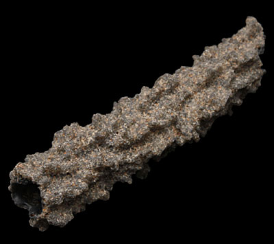
What is a lightning rod?
Lightning rods (also called conductors) are metal rods or similar objects that divert lightning safely to the ground, they can often be seen at the top of tall buildings.
What is hail?
Hail is a variety of differently shaped ice balls or lumps. Hail or hailstones are made up of water ice and can be any size; it can be measured anything from five millimetres and two hundred millimeters. Hail is produced during thunderstorms and heavy rains.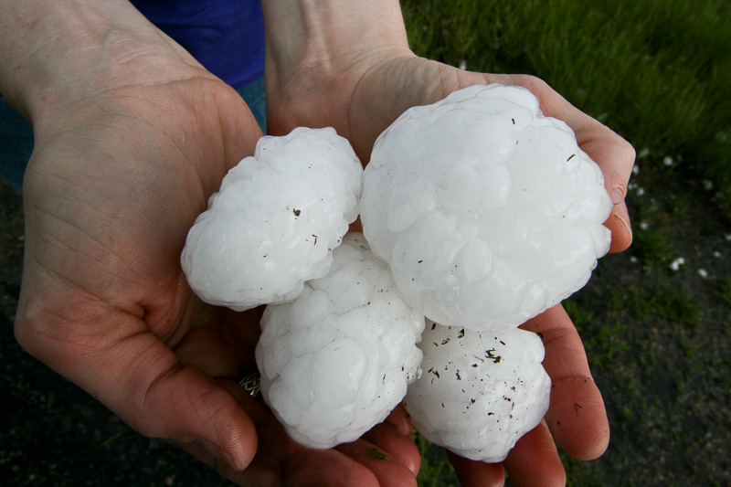
What is a hailstorm?
A hailstorm is a thunderstorm that produces hail.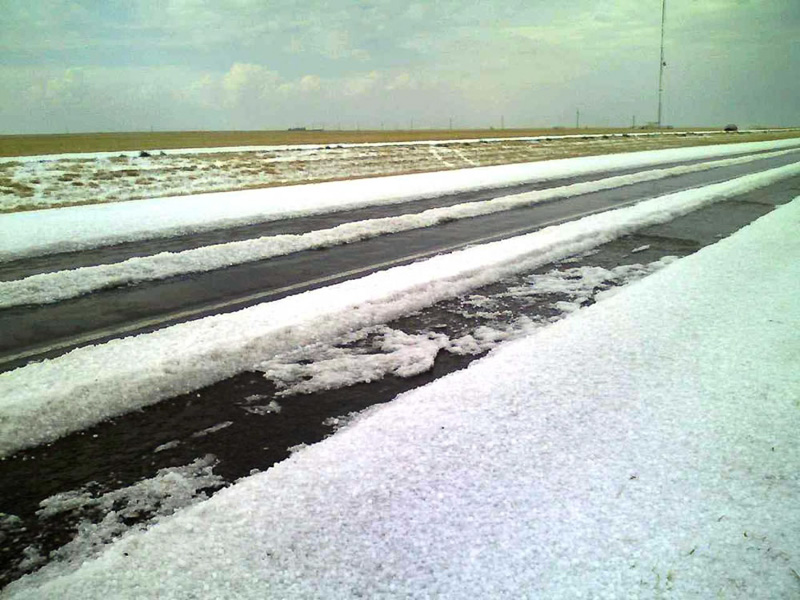
How does hail form?
Hail is created when small water droplets are caught in the updraft of a thunderstorm. These water droplets are lifted higher and higher into the sky until they freeze into ice. Once they become heavy, they will start to fall. If the smaller hailstones get caught in the updraft again, they will get more water on them and get lifted higher in the sky and get bigger. Once they get lifted again, they freeze and fall. This happens over and over again until the hailstone is too heavy and then falls to the ground.
How does hail fall to the ground?
Hail falls when it becomes heavy enough to overcome the strength of the updraft and is pulled by gravity towards the earth. How it falls is dependent on what is going on inside the thunderstorm. Hailstones bump into other raindrops and other hailstones inside the thunderstorm, and this bumping slows down their fall. Drag and friction also slow their fall, so it is a complicated question! If the winds are strong enough, they can even blow hail so that it falls at an angle. This would explain why the screens on one side of a house can be shredded by hail and the rest are unharmed!
How fast does hail fall?
We really only have estimates about the speed hail falls. One estimate is that a 1cm hailstone falls at 9 m/s, and an 8cm stone, weighing .7kg falls at 48 m/s (171 km/h). However, the hailstone is not likely to reach terminal velocity due to friction, collisions with other hailstones or raindrops, wind, the viscosity of the wind, and melting. Also, the formula to calculate terminal velocity is based on the assumption that you are dealing with a perfect sphere. Hail is generally not a perfect sphere!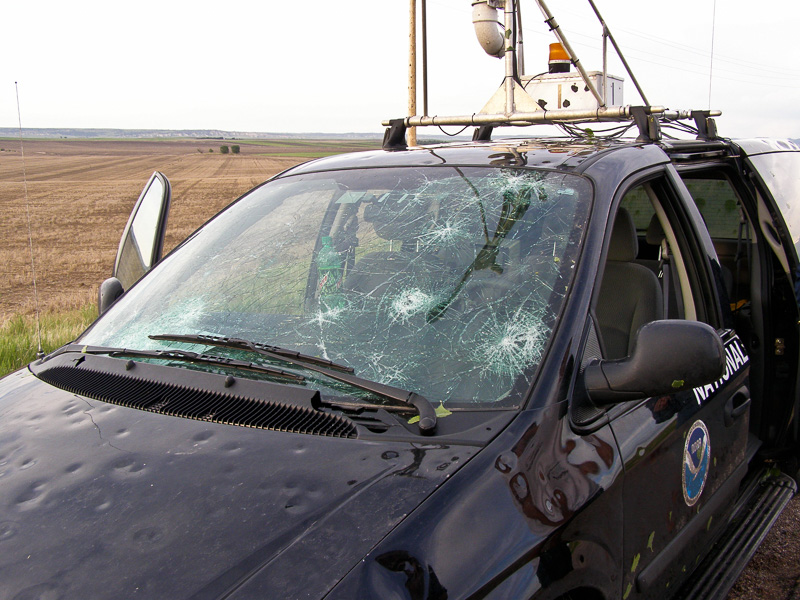
What areas have the most hail?
Though Florida has the most thunderstorms, Nebraska, Colorado, and Wyoming usually have the most hail storms. The area where these three states meet – “hail alley,” averages seven to nine hail days per year. The reason why this area gets so much hail is that the freezing levels (the area of the atmosphere at 32 degrees or less) in the high plains are much closer to the ground than they are at sea level, where hail has plenty of time to melt before reaching the ground. Other parts of the world that have damaging hailstorms include China, Russia, India and northern Italy.
Does hail fall in paths?
When viewed from the air, it is evident that hail falls in paths known as hail swaths. They can range in size from a few acres to an area 10 miles wide and 100 miles long. Piles of hail in hail swaths have been so deep, a snow plow was required to remove them, and occasionally, hail drifts have been reported.
How large can hail get?
Hail is usually pea-sized to marble-sized, but big thunderstorms can produce big hail. The largest hailstone recovered in the U.S. fell in Vivian, SD on June 23, 2010 with a diameter of 8 inches and a circumference of 18.62 inches. It weighed 1 lb 15 oz.
What types of thunderstorms produce large hail?
Supercell thunderstorms have sustained updrafts that support large hail formation by repeatedly lifting the hailstones into the very cold air at the top of the thunderstorm cloud. In general, hail 2 inches (5 cm) or larger in diameter is associated with supercells. Non-supercell storms are capable of producing golf ball size hail.
How is hail measured?
Hail size is estimated by comparing it to a known object. Most hail storms are made up of a mix of sizes, and only the very largest hail stones pose serious risk to people caught in the open.
- Pea = 1/4 inch diameter
- Marble/mothball = 1/2 inch diameter
- Dime/Penny = 3/4 inch diameter
- Nickel = 7/8 inch
- Quarter = 1 inch — hail quarter size or larger is considered severe
- Ping-Pong Ball = 1 1/2 inch
- Golf Ball = 1 3/4 inches
- Tennis Ball = 2 1/2 inches
- Baseball = 2 3/4 inches
- Tea cup = 3 inches
- Grapefruit = 4 inches
- Softball = 4 1/2 inches
Can meteorologists detect when hail is going to form in a thunderstorm?
Meteorologists can predict when thunderstorms are going to happen and can detect hailstorms and hail occurring. This can be done through weather radar imagery and satellites used especially for predicting weather and weather changes. When the hail is created and are larger than normal or average size, then they will fall at greater speeds. However, things such as friction with wind and air; and melting and the hail’s interaction with other hailstones and rain can slow down the speeds.![]()
What kind of damage does hail cause?
Hail can actually cause a lot of damage especially to cars and vehicles, aircrafts, buildings, crops and animals. More often than not, it is the roofs which take full effects of the hailstorm damage and can cause cracks in buildings and leaks in the roof. Hailstorms are very troublesome to drivers of vehicles because they can reign down on vehicles and cause a lot of damage to roofs, hoods and even come crashing through sunroofs. Windshields are often the target of hailstones and can crack or shatter them completely.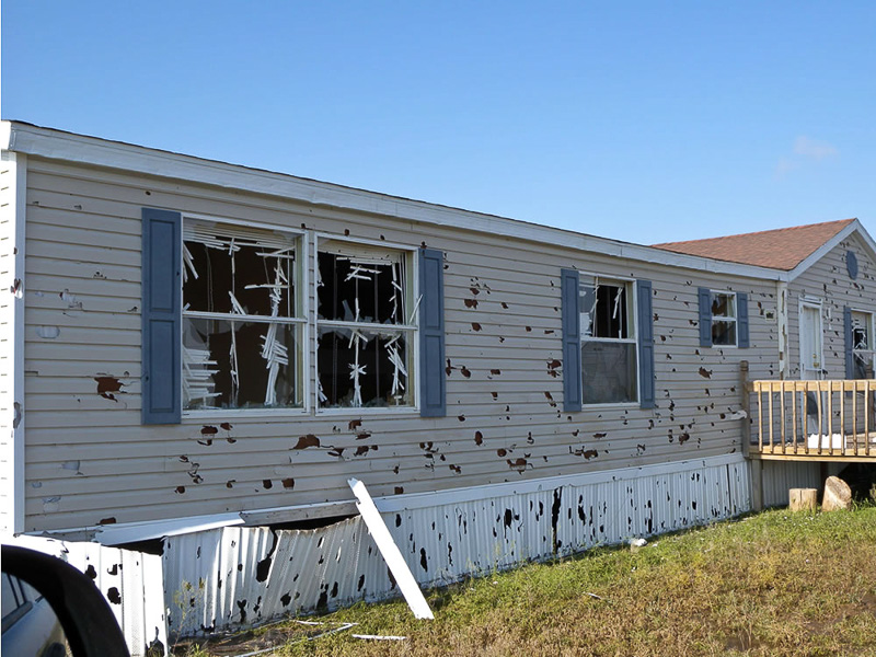
Why does the sky look green during some hail storms?
Scientists don’t agree on why the sky may appear green during severe weather, although there is plenty of anecdotal evidence that it can mean hail may be nearby. One theory is that large amounts of water and ice in a severe thunderstorm will scatter green light during the strong updrafts that occur in severe storms.
What causes the wind to blow?
As the sun warms the Earth’s surface, the atmosphere warms too. Some parts of the Earth receive direct rays from the sun all year and are always warm. Other places receive indirect rays, so the climate is colder. Warm air, which weighs less than cold air, rises. Then cool air moves in and replaces the rising warm air. This movement of air is what makes the wind blow.
What are damaging winds?
Damaging winds are often called “straight-line” winds to differentiate the damage they cause from tornado damage. Strong thunderstorm winds can come from a number of different processes. Most thunderstorm winds that cause damage at the ground are a result of outflow generated by a thunderstorm downdraft. Damaging winds are classified as those exceeding 50-60 mph.
What are straight-line winds?
Straight-line wind is a term used to define any thunderstorm wind that is not associated with rotation, and is used mainly to differentiate from tornadic winds.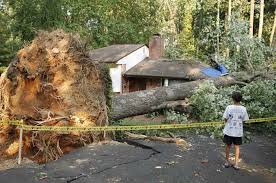
What is a downdraft?
A downdraft is a small-scale column of air that rapidly sinks toward the ground.
What is a downburst?
A downburst is a result of a strong downdraft. A downburst is a strong downdraft with horizontal dimensions larger than 2.5 miles (4 km) resulting in an outward burst of damaging winds on or near the ground. Imagine the way water comes out of a faucet and hits the bottom of the sink. Downburst winds may begin as a microburst and spread out over a wider area, sometimes producing damage similar to a strong tornado. Although usually associated with thunderstorms, downbursts can occur with showers too weak to produce thunder.
What is a microburst?
A microburst is a small concentrated downburst that produces an outward burst of damaging winds at the surface. Microbursts are generally small (less than 4km across) and short-lived, lasting only 5-10 minutes, with maximum windspeeds up to 168 mph.
What is the difference between a microburst and a downburst?
A microburst is less than 4 km across, and a downburst is greater than 4 km across.
What are the different types of microbursts?
There are two kinds of microbursts: wet and dry. A wet microburst is accompanied by heavy precipitation at the surface. Dry microbursts, common in places like the high plains and the intermountain west, occur with little or no precipitation reaching the ground.
What is a gust front?
A gust front is the leading edge of rain-cooled air that clashes with warmer thunderstorm inflow. Gust fronts are characterized by a wind shift, temperature drop, and gusty winds out ahead of a thunderstorm. Sometimes the winds push up air above them, forming a shelf cloud or detached roll cloud.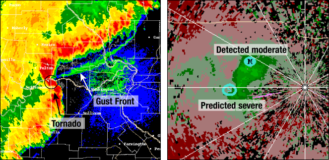
What is a gustnado?
A gustnado is a short-lived, ground-based swirling wind that can form on the leading edge of a severe thunderstorm. Although the name comes from “gust front of a tornado,” and a gustnado almost looks like a tornado, it is not considered to be one. A gustnado develops in a different way than a classic tornado does.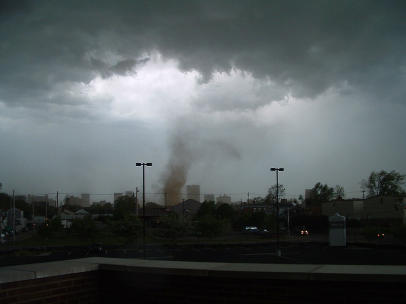
What is a derecho?
A derecho is a widespread, long-lived wind storm that is associated with a band of rapidly moving showers or thunderstorms. A typical derecho consists of numerous microbursts, downbursts, and downburst clusters. By definition, if the wind damage swath extends more than 240 miles (about 400 kilometers) and includes wind gusts of at least 58 mph (93 km/h) or greater along most of its length, then the event may be classified as a derecho.
What is a haboob?
A haboob is a wall of dust that is pushed out along the ground from a thunderstorm downdraft at high speeds.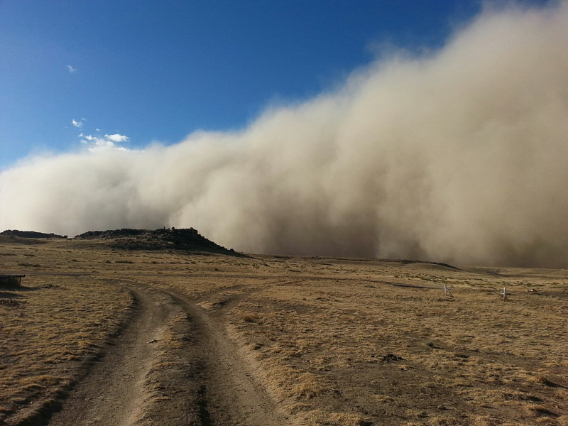
Are damaging winds really a big deal?
Damage from severe thunderstorm winds account for half of all severe reports in the lower 48 states and is more common than damage from tornadoes. Wind speeds can reach up to 100 mph and can produce a damage path extending for hundreds of miles.
Who is at risk from damaging winds?
Since most thunderstorms produce some straight-line winds as a result of outflow generated by the thunderstorm downdraft, anyone living in thunderstorm-prone areas of the world is at risk for experiencing this hazard. People living in mobile homes are especially at risk for injury and death. Even anchored mobile homes can be seriously damaged when winds gust over 80 mph.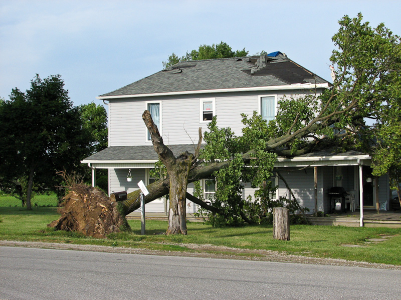
How are damaging winds detected?
Doppler radar is a critical tool for damaging wind detection because these hazards have certain patterns in the data collected near the surface and in middle levels of the storm. Doppler radar velocity data can show areas of diverging winds at the surface, and even the strength of those winds, indicating a downburst or microburst. Winds coming together at upper levels of the storm (convergence) can also be seen on velocity displays, and can indicate the development of a downburst or microburst.
What is a bow echo?
A bow echo is a radar echo that is linear but bent outward in a bow shape. Damaging straight-line winds often occur near the “crest” or center of a bow echo. Areas of circulation also can develop at either end of a bow echo, which sometimes can lead to tornado formation – especially in the left (usually northern) end, where the circulation shows cyclonic rotation.
SEVERE THUNDERSTORM WATCH – A severe thunderstorm (damaging winds of 58 miles per hour or more, or 1″ hail in diameter or greater) is likely to develop in your area.
SEVERE THUNDERSTORM WARNING – A severe thunderstorm (damaging winds of 58 miles per hour or more, or hail three-fourths of an inch in diameter or greater) is taking place in your area.
DOWNDRAFT – A sudden descent of cool or cold air to the ground, usually with precipitation, and associated with a thunderstorm or shower.
UPDRAFT – A warm column of air that rises within a cloud. If the air is sufficiently moist, then the moisture condenses to become a cumulus cloud.
- The typical thunderstorm is 15 miles in diameter and lasts an average of 30 minutes.
- Thunderstorms happen in every state and every thunderstorm has lightning.
- Thunderstorms may occur singly, in clusters, or in lines.
- Some of the most severe occur when a single thunderstorm affects one location for an extended time.
- Thunderstorms typically produce heavy rain for a brief period, anywhere from 30 minutes to an hour.
- Warm, humid conditions are highly favorable for thunderstorm development.
- About 10 percent of thunderstorms are classified as severe—one that produces hail at least three-quarters of an inch in diameter, has winds of 58 miles per hour or higher, or produces a tornado.
Click Here to see if there are any active warnings in your area.
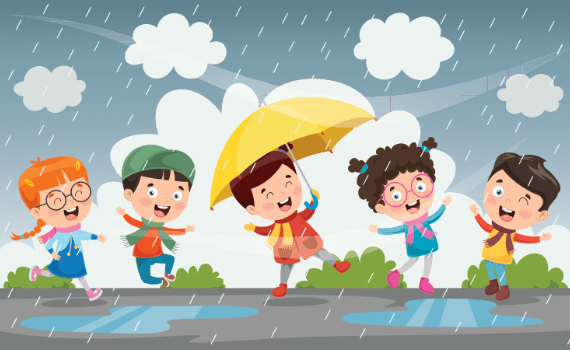
IF YOU’RE OUTDOORS: Keep an eye at the sky. Look for darkening skies, flashes of lightning, or increasing winds. Lightning often proceeds rain, so don’t wait for the rain to begin. If you hear the sound of thunder, go to a safe place immediately. The best place to go is a sturdy building or a car, but make sure the windows in the car are shut. Avoid sheds, picnic areas, baseball dugouts and bleachers.
If there is no shelter around you, stay away from trees. Crouch down in the open area, keeping twice as far away from a tree as far as it is tall. Put your feet together and place your hands over your ears to minimize hearing damage from thunder. If you’re with a group of people stay about 15 feet from each other. Stay out of water, because it’s a great conductor of electricity. Swimming, wading, snorkeling and scuba diving are not safe. Also, don’t stand in puddles and avoid metal. Stay away from clotheslines, fences, and drop your backpacks because they often have metal on them. If you’re playing an outdoor activity, wait at least 30 minutes after the last observed lightning strike or thunder.
IF YOU’RE INDOORS: Avoid water. It’s a great conductor of electricity, so do not take a shower, wash your hands, wash dishes or do laundry. Do not use a corded telephone. Lightning may strike exterior phone lines. Do not use electric equipment like computers and appliances during a storm. Stay away from windows and doors and stay off porches.
IF SOMEONE IS STRUCK BY LIGHTNING: Call for help. Call 9-1-1 or send for help immediately. The injured person does not carry an electrical charge, so it is okay to touch them.
Make Lightning In Your Mouth Experiment: Here is a great experiment that allows kids to make lightning in their mouth. It’s a great way for them to understand how lightning works.
What’s Lightning Experiment: Here is a great experiment that allows the kids to make lightning. All you need is a balloon and a light bulb!
Make Lightning Experiment: Here is another great experiment that allows the kids to make lightning. This teaches kids about the positive and negative charges and where they come from.
Sticking A Balloon To A Wall Experiment: Here is an experiment that allows the kids to learn about static electricity by sticking a balloon to a wall. This teaches kids about the positive and negative charges and where they come from.
Bend Water Experiment: Here is another static electricity experiment that bends water. This teaches kids about the positive and negative charges and where they come from.
Make Your Hair Stand Up Experiment: Here is yet another static electricity experiment with using a balloon and your hair. This teaches kids about the positive and negative charges and where they come from.
Make Thunder Experiment: This experiment allows kids to make thunder, in a way that allows them to understand how it is made by lightning.
Track A Thunderstorm Experiment: Here is a great way to teach kids how to track a thunderstorm.
Make A Thunderstorm Experiment: Here is a great experiment that shows kids how our weather works. It teaches them how thunderstorms are formed!
Science Fair Project Ideas: Here is a complete list of science fair project ideas. Discover the science behind the weather that impacts us every day.