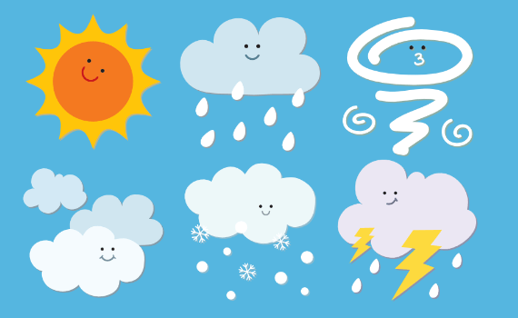
Weather
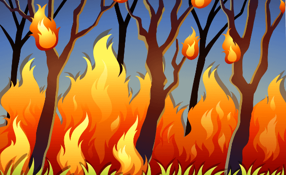
Natural Disasters

Experiments

Kid's Zone
Hurricanes
- Hurricane Questions
- Hurricanes…Past & Present
- Hurricane Definitions
- Hurricane Stages
- Saffir-Simpson Hurricane Scale
- Hurricane Safety
- Evacuation Tips
- Hurricane Supply Checklist
- Hurricane Activities
What is a hurricane?
A hurricane is a huge storm! It can be up to 600 miles across and have strong winds spiraling inward and upward at speeds of 75 to 200 mph. Each hurricane usually lasts for over a week, moving 10-20 miles per hour over the open ocean. Hurricanes gather heat and energy through contact with warm ocean waters. Evaporation from the seawater increases their power. Hurricanes rotate in a counter-clockwise direction around an “eye” in the Northern Hemisphere and clockwise direction in the Southern Hemisphere. The center of the storm or “eye” is the calmest part. It has only light winds and fair weather. When they come onto land, the heavy rain, strong winds and large waves can damage buildings, trees and cars.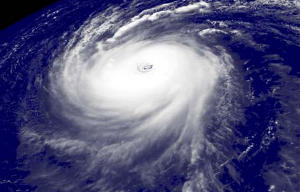
How do hurricanes form?
Hurricanes only form over really warm ocean water of 80°F or warmer. The atmosphere (the air) must cool off very quickly the higher you go. Also, the wind must be blowing in the same direction and at the same speed to force air upward from the ocean surface. Winds flow outward above the storm allowing the air below to rise. Hurricanes typically form between 5 to 15 degrees latitude north and south of the equator. The Coriolis Force is needed to create the spin in the hurricane and it becomes too weak near the equator, so hurricanes can never form there.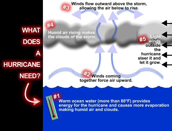
Hurricane Tracking Charts
Atlantic Ocean
Eastern Pacific
What is storm surge?
Storm surges are frequently the most devastating element of a hurricane. As a hurricane’s winds spiral around and around the storm, they push water into a mound at the storm’s center. This mound of water becomes dangerous when the storm reaches land because it causes flooding along the coast. The water piles up, unable to escape anywhere but on land as the storm carries it landward. A hurricane will cause more storm surge in areas where the ocean floor slopes gradually. This causes major flooding.
As you watch the storm-surge animations, notice the effect that the physical geography of each coastline has on storm surge. Also, note the waves on top of the ocean’s surface. Wind, waves, and sea-level rise all contribute to storm-surge damage.
Shallow-Water Coastline
Deep-Water Coastline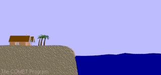
With technology the way it is, there are computer models that allow forecasters to predict the amount of storm surge that will affect a coastal area. These are called Slosh Models and take into account a storm’s strength, its path, how the ocean shallows, and the shape of the land. Then it calculates how much storm surge a hurricane will probably cause.
When does hurricane season start?
The Atlantic hurricane season is from June 1 to November 30, but most hurricanes occur during the fall months. The Eastern Pacific hurricane season is from May 15 to November 30. (Below is a graphic that shows you when hurricanes are most active across parts of the world.)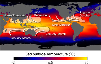
Who names hurricanes?
From 1950 to 1952, tropical cyclones of the North Atlantic Ocean were identified by the phonetic alphabet (Able-Baker-Charlie-etc.), but in 1953 the US Weather Bureau switched to women’s names. The rest of the world eventually caught on, and naming rights now go by the World Meteorological Organization, which uses different sets of names depending on the part of the world the storm is in. Around the U.S., only women’s names were used until 1979, when it was decided that they should alternate a list that included men’s names too. There’s 6 different name lists that alternate each year. If a hurricane does significant damage, its name is retired and replaced with another.
Atlantic Hurricane Names
Eastern Pacific Hurricane Names
What is the difference between a hurricane and a typhoon?
Nothing except geography. Tropical storms occur in several of the world’s oceans, and except for their names, they are essentially the same type of storm. In the Atlantic Ocean, Gulf of Mexico, and the Eastern Pacific Ocean, they are called hurricanes. In the Western Pacific Ocean, they are called typhoons. In the Indian Ocean, the Bay of Bengal, and Australia, these types of storms are called cyclones.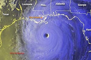
Who are the “Hurricane Hunters”?
The brave “hurricane hunters” work for the National Oceanic and Atmospheric Administration (NOAA). Each mission lasts about ten hours, with the crews passing four to six times through the storm. The planes carry radar, sophisticated computers, and weather instruments that determine characteristics such as temperature, air pressure, wind speed, and wind direction inside the hurricane. The crews also release instruments that measure temperature, air pressure, and wind at different levels as the devices drop through the hurricane toward the ocean. By mission’s end, NOAA can warn everyone in the hurricane’s path. Below is a photo of the hurricane hunters taking measurements inside Hurricane Katrina.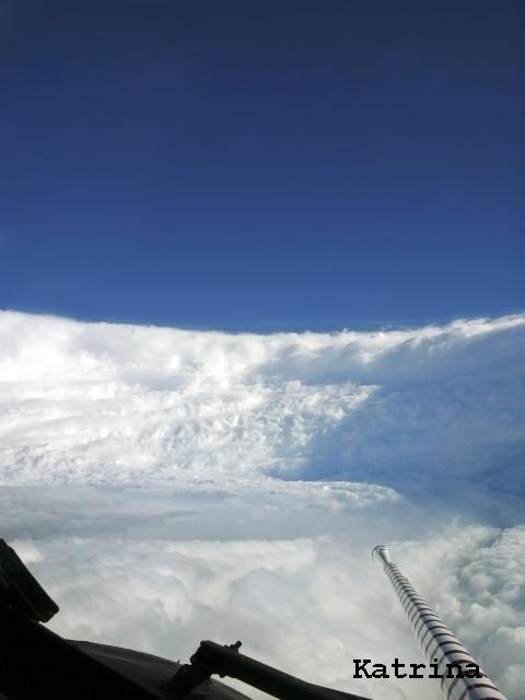
What is coastal beach erosion?
Coastal beach erosion is the wearing away of land, the removal of beach or dune sediments by wave action, tidal currents, wave currents, or drainage. Waves are generated by storms, wind, or hurricanes and can cause coastal erosion. This may take the form of long-term losses of sediment and rocks, or merely the temporary redistribution of coastal sediments.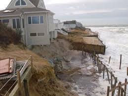
Tropical Tracks: Click to see the tracks of this year’s storms.
Past Hurricane Info: Click to find all the data and information about a specific hurricane by just knowing the year.
TROPICAL STORM WATCH – Tropical Storm conditions with sustained winds from 39 -74 mph are possible in your area within the next 36 hours.
TROPICAL STORM WARNING – Tropical Storm conditions are expected in your area within the next 24 hours.
HURRICANE WATCH – Hurricane conditions with sustained winds of 74 mph or greater are possible in your area within the next 36 hours. This WATCH should trigger your family’s disaster plan, and protective measures should be initiated. Especially, those actions that require extra time such as securing a boat and leaving a barrier island.
HURRICANE WARNING – Hurricane conditions are expected in your area within 24 hours. Once this WARNING has been issued, your family should be in the process of completing protective actions and deciding the safest location to be during the storm.
COASTAL FLOOD WATCH – The possibility exists for the inundation of land areas along the coast within the next 12 to 36 hours.
COASTAL FLOOD WARNING – Land areas along the coast are expected to become, or have become, inundated by sea water above the typical tide action.
SMALL CRAFT ADVISORY – A small craft advisory is a type of warning issued by the National Weather Service, most frequently in coastal areas. It is issued when winds have reached, or are expected to reach within 12 hours, a speed marginally less than that which is considered gale force, usually 25-38 mph.
Click Here to see if there are any active warnings in your area.
Tropical Wave – A low pressure trough moving generally westward with the trade winds.
Tropical Disturbance – An organized area of thunderstorms that usually forms in the tropics. Typically, they maintain their identity for 24 hours and are accompanied by heavy rains and gusty winds.
Tropical Cyclone – A generic term for any organized low pressure that develops over tropical and sometimes sub-tropical waters. Tropical depressions, tropical storms, and hurricanes are all example of tropical cyclones.
Tropical Depression – An organized area of low pressure in which sustained winds are 38 mph or less.
Tropical Storm – A tropical cyclone with maximum sustained wind speeds that range from 39 to 73 mph.
Hurricane – A tropical cyclone with sustained winds of at least 74 mph.
| Category | Winds (MPH) |
Pressure (Millibars) | Pressure (Inches) | Storm Surge (Feet) |
Damage |
| 1 | 74-95 | <980 | <28.94 | 4′-5′ | Minimal |
| 2 | 96-110 | 979-965 | 28.91-28.50 | 6′-8′ | Moderate |
| 3 | 111-130 | 964-945 | 28.47-27.91 | 9′-12′ | Extensive |
| 4 | 131-155 | 944-920 | 27.88-27.17 | 13′-18′ | Extreme |
| 5 | >155 | <920 | <27.17 | >18′ | Catastrophic |
To learn more about hurricanes, Click Here to watch a variety of videos teaching you the ins and outs of nature’s fury. I would like to give a special thanks to Pinellas County Emergency management for putting these instructional videos together.
BEFORE A HURRICANE: Have a disaster plan and a pet plan ready. Before a storm threatens, contact your veterinarian or local humane society for information on preparing your pets for an emergency. Board up windows and bring in outdoor objects that could blow away. Make sure you know which county or parish you live in and know where all the evacuation routes are. Prepare a disaster supplies kit for your home and car. Include a first aid kit, canned food and a can opener, bottled water, battery-operated radio, flashlight, protective clothing and written instructions on how to turn off electricity, gas, and water. Have a NOAA weather radio handy with plenty of batteries, so you can listen to storm advisories. Have some cash handy as well, because following a hurricane, banks and ATMs may be temporarily closed. Make sure your car is filled with gasoline.
DURING A HURRICANE: Stay away from low-lying and flood prone areas. Always stay indoors during a hurricane, because strong winds will blow things around. Leave mobile homes and to go to a shelter. If your home isn’t on higher ground, go to a shelter. If emergency managers say to evacuate, then do so immediately.
AFTER A HURRICANE: Stay indoors until it is safe to come out. Check for injured or trapped people, without putting yourself in danger. Watch out for flooding which can happen after a hurricane. Do not attempt to drive in flooding water. Stay away from standing water. It may be electrically charged from underground or downed power lines. Don’t drink tap water until officials say its safe to do so.
Stay alert to storm advisories by using your NOAA weather radio.
- Enact your family disaster plan.
- Map out your route. Use travel routes specified by local authorities.
- Do not get on the road without a place to go.
- Fill your car with gasoline.
- Enact your pet plan. Before a storm threatens, contact your veterinarian or local humane society for information on preparing your pets for an emergency.
- Bring your disaster supply kit. Make sure you include important documents. Have enough food and water for at least 3 days. Bring flashlights for emergency lightning, since it’s likely that there will be power outages and most places will be running on backup power.
- Secure your home before leaving. Board up windows and glass doors, anchor loose objects or bring them inside and lock your doors.
- Have some cash handy. Following a hurricane, banks and ATMs may be temporarily closed.
- Notify your family and friends of your plans.
WHEN EVACUATING:
- If possible, evacuate to the home of either friends or family in a non-vulnerable area within your county or parish.
- Next, try a hotel.
- As a last result, go to a public shelter. Remember, shelters are not designed for comfort and do not usually accept pets.
Here is a list of what what you will need for 3 to 5 days if you chose to stay at your home during a hurricane.
- Drinking Water Battery-operated Weather Radio
- Canned Food Portable Alarm Clock
- Manual Can Opener Extra Batteries
- Extra Prescription Medicine Flashlights
- Eating Utensils Rope
- First Aid Kit Hammer and Nails
- Trash Bags Duct Tape
- Cash Extension Cords
- Pillows and Blankets Tarp
- Sleeping Bags Mosquito Repellent
- Water Jugs Cleaning Supplies
As far as tools are concerned, the following are a must. Remember, power tools may be useless for several days after a storm.
- Hand Saw (8 or 10 point)
- Claw Hammer
- Shovel
- Push Broom
- Screw Drivers
- Limb Saw (pruning saw)
- Vice Grips
- Utility Knife
- Cotton Work Gloves
Lesson Plan: Here is a great lesson plan on learning about hurricane safety. In this activity, Owlie teaches kids about hurricanes and quizzes them about what they learned. Note: This is a PDF file, so you need to have Adobe Acrobat Reader.
Lesson Plan: Here is a great lesson plan on understanding hurricanes. Students will learn how wind speed increases the height and why higher waves occur in shallower water. This activity is for grades 6-8.
Lesson Plan: Here is a great lesson plan on elementary reading comprehension. This lesson contains a broader vocabulary, more hurricane facts, and more thought-provoking writing prompts. It works well for grades 3-5. Note: This is a PDF file, so you need to have Adobe Acrobat Reader.
Lesson Plan: Here is a great interactive lesson plan on allowing kids to create their very own hurricane. It lets you try to create ideal hurricane conditions by changing the winds, latitude, moisture, and sea temperature. It even keeps score! This is a great activity for 5-8th graders.
Lesson Plan: Here is a great interactive lesson plan that lets kids aim a hurricane. It lets you move the hurricane symbol, high pressure symbol and low pressure symbol to track your very own hurricane. Sometimes your hurricane will make landfall, other times it misses the U.S. all together. It lets kid understand how important the setup of weather impacts where hurricanes go.
Suck An Egg Into A Bottle Experiment: Here is an experiment that shows how pressure is created in our atmosphere by sucking an egg in a bottle. This is a very cool experiment!
Make Your Own Barometer I Experiment: Here is an experiment that allows the kids to make a barometer.
Make Your Own Barometer II Experiment: Here is an experiment that allows the kids to make a barometer.
Create Evaporation Experiment: Here is an experiment that shows kids how evaporation takes place.
Science Fair Project Ideas: Here is a complete list of science fair project ideas. Discover the science behind the weather that impacts us every day.