Weather
Natural Disasters

Experiments
Kid's Zone
Tornadoes
- Tornado Questions
- Tornado Definitions
- Tornado Facts
- Enhanced Fujita Scale of Tornado Intensity
- Tornado Safety
- Tornado Activities
What is a tornado?
A tornado is a violent rotating column of air extending from a thunderstorm to the ground. The most violent tornadoes are capable of tremendous destruction with wind speeds of up to 300 mph. They can destroy large buildings, uproot trees and hurl vehicles hundreds of yards. They can also drive straw into trees. Damage paths can be in excess of one mile wide to 50 miles long. In an average year, 1000 tornadoes are reported nationwide.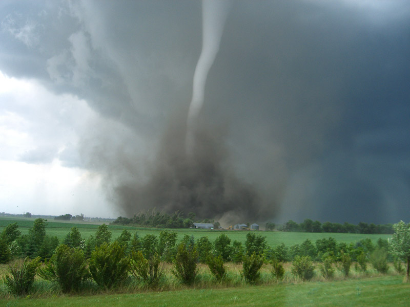
How do tornadoes form?
Most tornadoes form from thunderstorms. You need warm, moist air from the Gulf of Mexico and cool, dry air from Canada. When these two air masses meet, they create instability in the atmosphere. A change in wind direction and an increase in wind speed with increasing height creates an invisible, horizontal spinning effect in the lower atmosphere. Rising air within the updraft tilts the rotating air from horizontal to vertical. An area of rotation, 2-6 miles wide, now extends through much of the storm. Most strong and violent tornadoes form within this area of strong rotation.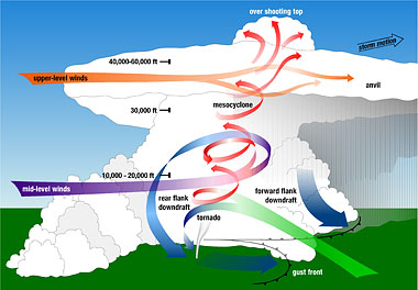
Click Here to learn more about tornadoes from NOAA.
What are some other factors for tornadoes to form?
Several conditions are required for the development of tornadoes and the thunderstorm clouds with which most tornadoes are associated. Abundant low level moisture is necessary to contribute to the development of a thunderstorm, and a “trigger” (perhaps a cold front or other low level zone of converging winds) is needed to lift the moist air aloft. Once the air begins to rise and becomes saturated, it will continue rising to great heights to produce a thunderstorm cloud, if the atmosphere is unstable. An unstable atmosphere is one where the temperature decreases rapidly with height. Atmospheric instability can also occur when dry air overlays moist air near the earth’s surface. Finally, tornadoes usually form in areas where winds at all levels of the atmosphere are not only strong, but also turn with height in a clockwise or veering direction.
What do tornadoes look like?
Tornadoes can appear as a traditional funnel shape, or in a slender rope-like form. Some have a churning, smoky look to them, and other contain “multiple vortices”, which are small, individual tornadoes rotating around a common center. Even others may be nearly invisible, with only swirling dust or debris at ground levels as the only indication of the tornado’s presence.
Can more than one tornado form at a time?
Yes, one way that twin tornadoes can occur is through a processes called occlusion. This happens when one tornado starts to dissipate as cool, moist air wraps around the tornado while another tornado begins to form in a more favorable part of the thunderstorm. Another term for this is cycling and that process is fairly common in very strong thunderstorms. The overlap time for both tornadoes to be on the ground concurrently is a very short time. Another way two tornadoes can form is from a multiple-vortex tornado. This occurs when much smaller, rapidly spinning whirls rotate inside a larger tornado – also termed “suction vortices”. These “suction vortices” inside of a larger tornado are usually responsible for some of the most intense damage in a tornadoes path. This is because of smaller tornadoes inside the larger tornado have stronger winds and are spinning much faster than the larger tornado. The last way that twin tornadoes can occur is by satellite tornadoes. This occurs when a second tornado develops independently of the primary tornado. The satellite tornado orbits the primary tornado but is located inside the same mesocyclone – this means there are two separate areas of rotation occurring at the same time in the atmosphere.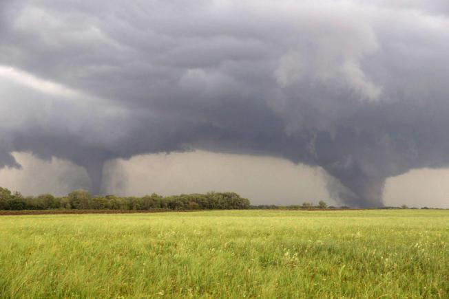
What is a funnel cloud?
A funnel cloud is a rotating cone-shaped column of air extending downward from the base of a thunderstorm, but not touching the ground. When it reaches the ground it is called a tornado.
What is a supercell thunderstorm?
A supercell thunderstorm is a long-lived thunderstorm whose updrafts and downdrafts are in near balance. These storms have the greatest tendency to produce tornadoes that stay on the ground for long periods of time. Supercell thunderstorms can produce violent tornadoes with winds exceeding 200 mph.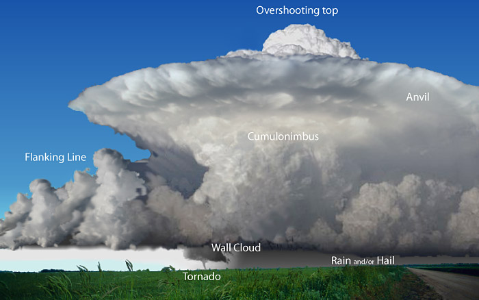
What is a mesocyclone?
A mesocyclone is a rotating vortex of air within a supercell thunderstorm. Mesocyclones do not always produce tornadoes.
What is a microburst?
A microburst is a downdraft (sinking air) in a thunderstorm that is less than 2.5 miles in scale. Although microbursts are not as widely recognized as tornadoes, they can cause comparable, and in some cases, worse damage than some tornadoes produce. In fact, wind speeds as high as 150 mph are possible in extreme microburst cases.
What is a wall cloud?
A wall cloud is an abrupt lowering of a rain-free cumulonimbus base into a low-hanging accessory cloud. A wall cloud is usually situated in the southwest portion of the storm. A rotating wall cloud usually develops before tornadoes or funnel clouds.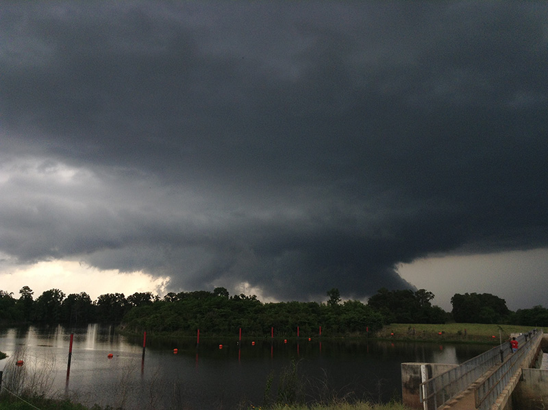
What is a hook echo?
A hook echo describes a pattern in radar reflectivity images that looks like a hook extending from the radar echo, usually in the right-rear part of the storm (relative to the motion of the storm). A hook is often associated with a mesocyclone and indicates favorable conditions for tornado formation. The hook is caused by the rear flank downdraft and is the result of precipitation wrapping around the back side of the updraft.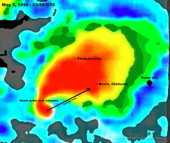
What is a waterspout?
A waterspout is just a weak tornado that forms over water. They are most common along the Gulf Coast. Waterspouts can sometimes move inland, becoming tornadoes causing damage and injuries.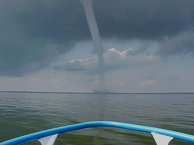
What is hail?
Hail is created when small water droplets are caught in the updraft of a thunderstorm. These water droplets are lifted higher and higher into the sky until they freeze into ice. Once they become heavy, they will start to fall. If the smaller hailstones get caught in the updraft again, they will get more water on them and get lifted higher in the sky and get bigger. Once they get lifted again, they freeze and fall. This happens over and over again until the hailstone is too heavy and then falls to the ground.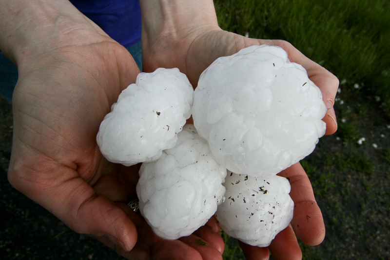
What is the largest hailstone recorded in the United States?
According to the National Weather Service, the largest hailstone is 8 inches in diameter and weights approximately 2 pounds. It fell in Vivian, South Dakota on July 23, 2010.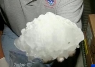
What is a gustnado?
A gustnado is a short-lived, relatively weak whirlwind that forms along a gust front. A gust front is the surge of very gusty winds at the leading edge of a thunderstorm’s outflow of air. Gustnadoes are not tornadoes. They do not connect with any cloud-base rotation. But because gustnadoes often have a spinning dust cloud at ground level, they are sometimes wrongly reported as tornadoes. Gustnadoes can do minor damage.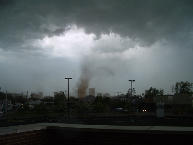
What is a landspout?
A landspout is a very weak tornado that is not associated with a wall cloud or a mesocyclone. It is the land equivalent of a waterspout.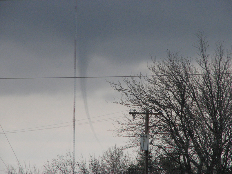
What is a dust devil?
A dust devil generally forms in the hot sun during the late morning or early afternoon hours. These are mostly harmless whirlwinds and are triggered by light desert breezes that create a swirling plume of dust with speeds rarely over 70 mph. These differ from tornadoes in that they are not associated with a thunderstorm (or any cloud) and are usually very weak.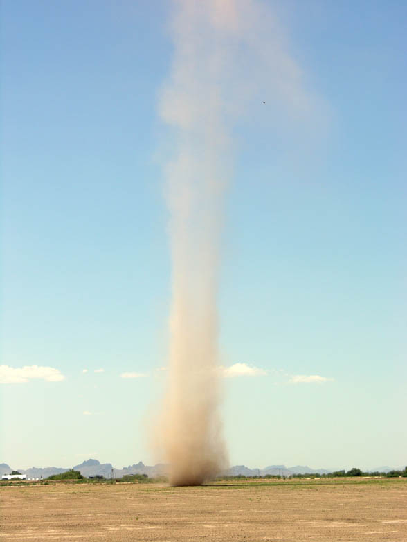
Where do tornadoes occur?
Tornadoes occur in many parts of the world, including Australia, Europe, Africa, Asia, and South America. Even New Zealand reports about 20 tornadoes each year. Two of the highest concentrations of tornadoes outside the U.S. are Argentina and Bangladesh.
How many tornadoes occur in the U.S. each year?
About 1,200 tornadoes hit the U.S. yearly. Since official tornado records only date back to 1950, we do not know the actual average number of tornadoes that occur each year. Plus, tornado spotting and reporting methods have changed a lot over the last several decades.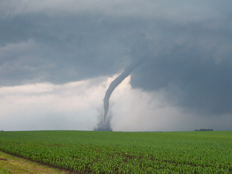
Where is Tornado Alley?
Tornado Alley is a nickname invented by the media for a broad area of relatively high tornado occurrence in the central U.S. Various Tornado Alley maps look different because tornado occurrence can be measured many ways: by all tornadoes, tornado county-segments, strong and violent tornadoes only, and databases with different time periods. Please remember, violent or killer tornadoes do happen outside “Tornado Alley” every year.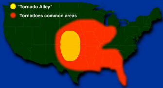
When are tornadoes most likely to occur?
Tornadoes can happen at any time of the year and at any time of the day. In the southern states, peak tornado season is from March through May. Peak times for tornadoes in the northern states are during the summer. A few southern states have a second peak time for tornado outbreaks in the fall. Tornadoes are most likely to occur between 3 p.m. and 9 p.m.
What are the wind speeds in a tornado?
We’re not really sure what the highest wind speed might be inside a tornado, since strong and violent tornadoes destroy weather instruments. We really only have measurements of the winds inside weaker tornadoes. Mobile Doppler radars can measure wind speeds in a tornado above ground level, and the strongest was 318 mph measured on May 3, 1999 near Bridge Creek/Moore, Oklahoma.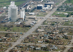
How fast do tornadoes move?
We don’t have detailed statistics about this. Movement can range from almost stationary to more than 60 mph. A typical tornado travels at around 10–20 miles per hour.
How long is a tornado usually on the ground?
Detailed statistics about the time a tornado is on the ground are not available. This time can range from an instant to several hours. The average is about five minutes.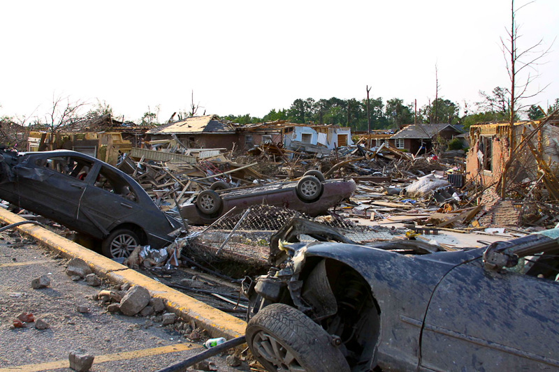
What does a tornado sound like?
People who have been in a tornado say it sounds like a jet engine or a freight train and is very loud. They said it hurt their ears, but they were more worried about what might happen to them than they were about the pain in their ears.
Can tornadoes be stopped?
You have to consider that the tornado is part of something bigger: the supercell thunderstorm. Unless you disrupt the supercell thunderstorm itself, you would likely have another tornado, even if you were able to destroy the first. The thunderstorm’s energy is much greater than the tornado. No one has tried to disrupt the tornado because the methods to do so could likely cause even more damage than the tornado. Detonating a nuclear bomb, for example, to disrupt a tornado would be even more deadly and destructive than the tornado itself. Lesser things (like huge piles of dry ice or smaller conventional weaponry) would be too hard to deploy in the right place fast enough, and would likely not have enough impact to affect the tornado much anyway.
TORNADO WATCH – Tornadoes are possible in your area. Stay tuned to the radio or television news.
TORNADO WARNING – A tornado is either on the ground or has been detected by Doppler radar. Seek shelter immediately!
INFLOW BANDS- These are ragged bands of low cumulus clouds extending from the main storm tower usually to the southeast or south. The presence of inflow bands suggests that the storm is gathering low-level air from several miles away. If the inflow bands have a spiraling nature to them, it suggests the presence of rotation.
BEAVER’S TAIL– The beaver’s tail is a smooth, flat cloud band extending from the eastern edge of the rain-free base to the east or northeast. It usually skirts around the southern edge of the precipitation area. It also suggests the presence of rotation.
WALL CLOUD– A wall cloud is an isolated cloud lowering attached to the rain-free base of the thunderstorm. The wall cloud is usually to the rear of the visible precipitation area. A wall cloud that may produce a tornado usually exists for 10–20 minutes before a tornado appears. A wall cloud may also persistently rotate (often visibly), have strong surface winds flowing into it, and may have rapid vertical motion indicated by small cloud elements quickly rising into the rain-free base. As the storm intensifies, the updraft draws in low-level air from several miles around. Some low-level air is pulled into the updraft from the rain area. This rain-cooled air is very humid; the moisture in the rain-cooled air quickly condenses below the rain-free base to form the wall cloud.
REAR FLANK DOWNDRAFT – The Rear Flank Downdraft (RFD) is a downward rush of air on the back side of the storm that descends along with the tornado. The RFD looks like a “clear slot” or “bright slot” just to the rear (southwest) of the wall cloud. It can also look like curtains of rain wrapping around the cloud base circulation. The RFD causes gusty surface winds that occasionally have embedded downbursts. The rear flank downdraft is the motion in the storm that causes the hook echo feature on radar.
CONDENSATION FUNNEL- A condensation funnel is made up of water droplets and extends downward from the base of the thunderstorm. If it is in contact with the ground it is a tornado; otherwise it is a funnel cloud. Dust and debris beneath the condensation funnel confirm a tornado’s presence.
Click Here to see if there are any active warnings in your area.
- Tornadoes can occur at any time of the year.
- No terrain is safe from tornadoes.
- Never open windows in severe weather situations. This allows damaging wind and debris to enter the structure.
- 69% of all tornadoes are labeled “weak tornadoes” meaning they have a lifetime of 1-10+ minutes and winds less than 110 mph.
- 29% of all tornadoes are labeled “strong tornadoes” meaning they last 20 minutes or longer and winds reach 110-205 mph.
- 2% of all tornadoes are labeled “violent tornadoes” and can last over an hour.
- Every state has had a tornado, but some states are more prone to them.
- Most tornadoes in the Northern Hemisphere spin counterclockwise, while most tornadoes in the Southern Hemisphere spin clockwise.
- The safest place to be during a tornado is underground, which makes basements and cellars the ideal shelters to get away from tornadoes.
- Most of the world’s destructive tornadoes occur during the the summer in mid-western states of the US.
- Sometimes multiple tornadoes form and travel together in swarms.
| ENHANCED OPERATIONAL FUJITA SCALE |
WIND SPEED | POSSIBLE DAMAGE |
| EF0 | 65-85 mph | Light damage: Branches broken off trees; minor roof damage |
| EF1 | 86-110 mph | Moderate damage: Trees snapped; mobile home pushed off foundations; roofs damaged |
| EF2 | 111-135 mph | Considerable damage: Mobile homes demolished; trees uprooted; strong built homes unroofed |
| EF3 | 136-165 mph | Severe damage: Trains overturned; cars lifted off the ground; strong built homes have outside walls blown away |
| EF4 | 166-200 mph | Devastating damage: Houses leveled leaving piles of debris; cars thrown 300 yards or more in the air |
| EF5 | over 200 mph | Incredible damage: Strongly built homes completely blown away; automobile-sized missiles generated |
BEFORE A TORNADO: Have a disaster plan. Make sure everyone knows where to go in case a tornado threatens. Make sure you know which county or parish you live in. Prepare a kit with emergency food for your home. Have enough food and water for at least 3 days.
DURING A TORNADO: Go to a basement. If you do not have a basement, go to an interior room without windows on the lowest floor such as a bathroom or closet. If you can, get under a sturdy piece of furniture, like a table. If you live in a mobile home get out. They offer little protection against tornadoes. Get out of automobiles. Do not try to outrun a tornado in your car, leave it immediately. If you’re outside, go to a ditch or low lying area and lie flat in it. Stay away from fallen power lines and stay out of damaged areas.
IF YOU’RE AT SCHOOL DURING A TORNADO: Every school should have a disaster plan and have frequent drills. Basements offer the best protection. Schools without basements should use interior rooms and hallways on the lowest floor away from windows. Crouch down on your knees and protect your head with your arms.
Crouch Down
AFTER A TORNADO: Stay indoors until it is safe to come out. Check for injured or trapped people, without putting yourself in danger. Watch out for downed power lines. Use a flashlight to inspect your home.
Lesson Plan: Here are some great lesson plans on learning about tornado safety. Note: This is a PDF file, so you need to have Adobe Acrobat Reader.
Tornado In A Bottle Experiment: Here is a great experiment that allows the kids to make a tornado in a bottle.
Tornado In A Jar Experiment: Here is a great experiment that allows the kids to make a tornado in a jar.
Suck An Egg Into A Bottle Experiment: Here is an experiment that shows how pressure is created in our atmosphere by sucking an egg in a bottle. This is a very cool experiment!
Make Your Own Barometer I Experiment: Here is an experiment that allows the kids to make a barometer.
Make Your Own Barometer II Experiment: Here is an experiment that allows the kids to make a barometer.
Create Evaporation Experiment: Here is an experiment that shows kids how evaporation takes place.
Science Fair Project Ideas: Here is a complete list of science fair project ideas. Discover the science behind the weather that impacts us every day.